MOSOELEA
Mosoelea Indian Tribe
Mosoelea
A problematic tribe, first noted on Marquette's map where "Monsoupelea" or "Monsoupera," is marked as an Indian village on the east bank of the Mississippi some distance below the mouth of the Ohio. In 1682 LaSalle found a Mosopela chief with 5 cabins of his people living with the Taensa, but whom they had been adopted after the destruction of their former village by some unknown enemy.
CHICKASAW
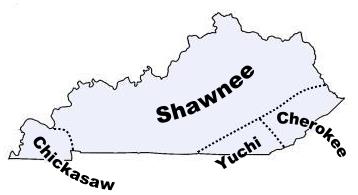
Chickasaw Indian History
Chickasaw
An important Muskhogean tribe, closely related to the Choctaw in language and customs, although the two tribes were mutually hostile. Aside from tradition, the earliest habitat traceable for the Chickasaw is north Mississippi. Their villages in the 18th century centered about Pontotoc and Union counties, where the headwaters of the Tombigbee meet those of Yazoo river and its affluent, the Tallahatchie, about where the De Soto narratives place them in 1540, under the name Chicaza. Their main landing place on the Mississippi was at Chickasaw Bluffs, now the site of Memphis, Tenn., whence a trail more than 160 miles long led to their villages. They had two other landing places farther up the Mississippi. Adair, who for many years was a trader among the Chickasaw and gives a full and circumstantial account of them (Hist. Am. Inds., 352-373, 1775), states that in 1720 they had four contiguous settlements, and that the towns of one of these were:
Shatara
Chook'heereso
Hykehah
Tuskawillao
Phalacheho
Two of the other settlements of which he gives the names were Yaneka, 6 miles long, and Chookka Phar·ah (Chukafalava), 4 miles long. Romans (Florida, 63, 1775, describing their country and villages, says that they "live nearly in the center of an uneven and large nitrous savannah; have in it 1 town, 1Ω miles long, very narrow and irregular; this they divide into 7 [towns] by the names of:
Amalahta 'hat and feather'
Chatelaw 'copper town'
Chukafalaya 'long town'
Hikkihaw 'stand still'
Chucalissa 'great town'
Tuckahaw 'a cert'n weed'
Ashukhuma 'red grass'
Formerly the whole was inclosed in "palisadoes."
The warlike Chickasaw claimed other territory far beyond the narrow limits of their villages, and extending on the north to the confluence of the Ohio with the Tennessee. They also claimed n large area north of the Tennessee to the ridge between Duck river and the Cumberland to the headwaters of Duck river and south to Chickasaw Old Fields on the Tennessee, thence along an indeterminate southeast line to the Mississippi. This claim was admitted by the Cherokee.
According to Haywood and other authorities an outlying colony of Chickasaw formerly dwelt on Savannah river nearly opposite Augusta, Ga., but trouble with the Creeks drove them westward again. In 1795 the Chickasaw claimed payment from the United States for the land on the Savannah thus occupied.
The Chickasaw were noted from remote times for their bravery, independence, and warlike disposition. They were constantly fighting with the neighboring tribes; sometimes with the Choctaw and Creeks, then with the Cherokee, Illinois, Kickapoo, Shawnee, Mobilians, Osage, and Quapaw. In 1732 they cut to pieces a war party of Iroquois who had invaded their country. They were constant enemies of the French, a feeling intensified by the intrigues of British traders and their hatred of the Choctaw who had entered into friendly relations with the French colonists. The Chickasaw urged the Natchez to resist the French encroachments, and gave shelter to them when driven from their home. They defeated the French at Amalahta in 1736, at the Long House and other points, and baffled their attempts at conquest in the war of 1739-40. They combined with the Cherokee about 1715 and drove the Shawnee from their home on the Cumberland, and in 1769 utterly routed, at Chickasaw Old Fields, these former Cherokee allies.
Their relations with the United States began with the Hopewell treaty in 1786, when their boundary on the north was fixed at the Ohio river. They began to emigrate west of the Mississippi as early as 1822, and treaties for the removal of those who remained in their old seats were made in 1832 and 1834. By the treaty of 1855 their lands in Indian Territory were definitely separated from those of the Choctaw, with which they had before been included.
In manners and customs they differed little from their congeners, the Choctaw, the principal difference being the more sedentary habits and greater devotion to agricultural pursuits by the Choctaw on the one hand, and the more turbulent, restless, and warlike disposition of the Chickasaw on the other. Their traditional origin is the same as that of the Creeks and Choctaw (q. v.), and is given in the so-called "Creek migration legend" (see Creeks). The Chickasaw appear to have sheltered and ultimately incorporated into their organization the small tribes along Yazoo river, who spoke substantially the same language.
The Chickasaw language served as a medium of commercial and tribal intercourse for all the tribes along the lower Mississippi. Early estimates of population vary widely, those of the 18th century ranging from 2,000 to nearly 6,000. According to Adair (op. cit., 353) they had been much more numerous than during his time (1744), one of the two divisions, the "Long House," numbering not more than 450 warriors, indicating a population of 1,600 to 1,800 persons. He gives no estimate of the other division, but assuming it to have been about the same, the population of the entire tribe was between 3,000 and 4,000. Morse (Rep. to Sec. War, 364, 1822), though estimating the Choctaw at 25,000, gives the Chickasaw population as 3,625. In 1865 the estimated population was 4,500; in 1904 the official number was given as 4,820, including mixed bloods.
Napissa (Choctaw: nanpisa, 'spy,' 'sentinel') A tribe mentioned in 1699 by Iberville as united with the Chickasaw living in villages adjoining hose of the later, and speaking the same or a cognate language. As they disappeared from history early in the 18th century, it is probably that they were absorbed by the Chickasaw, if indeed they were not a local division of the latter.
Chickasaw Indian Chiefs and Leaders
Colbert, William. A Chickasaw chief. During the Revolutionary war he aided the Americans, and in the army of Gen. Arthur St Clair led the Chickasaw allies against the hostile tribes and was known as the great war-chief of his nation. In the war of 1812 he served 9 months in the regular infantry, then returned to lead his warriors against the hostile Creeks, whom he pursued from Pensacola almost to Apalachicola, killing many and bringing back 85 prisoners to Montgomery, Ala. He was styled a general when he visited Washington at the head of a Chickasaw delegation in 1816. In the treaties ceding Chickasaw lands to the United States the name of Gen. Colbert appears, except in the ones to which was signed the name Piomingo, which also was borne by a captain of the Chickasaw in the St Clair expedition, and was the pseudonym under which John Robertson, "a headman and warrior of the Muscogulee nation," wrote The Savage (Phila., 1810).
Chickasaw Indian Gentes
According to Morgan (Anc. Society, 163, 1878) the Chickasaw were divided into 12 gentes, arranged in 2 phratries, as follows:
I-Koi, Panther
(1) Koinchnsh, Wild cat
(2) llatakfushi, Bird
(3) Nunni, Fish
(4) Issi, Deer
II. Ishpanee, Spanish:
(1) Shauee, Raccoon
(2) Ishpanee, Spanish
(3) Mingko, Royal
(4) Hushkoni, Skunk
(5) Tunni, Squirrel
(6) Hochouchabba, Alligator
(7) Nashola, Wolf
(8) Chuhhla, Blackbird
The list given by Gibbs (Gatschet, Creek Migr. Leg., I, 96, 1884) follows:
I.-Panther phratry, Koa:
(1) Kointchush, Wild cat
(2) Fushi, Bird
(3) Nanni, Fish
(4) Issi, Deer
II. Spanish phratry, Ishpani
(1) Shawi, Raccoon
(2) Ishpani, Spanish
(3) Mingo, Royal
(4) Huskoni
(5) Tunni, Squirrel
(6) Hotchon tehapa, Alligator
(7) Nashoba, Wolf
(8) Tchu'hla, Blackbird
Mingos or chiefs could be chosen only front the "Spanish" gens, and were hereditary in the female line. The name must formerly have been different or this rule must have been established after the coming of the Spaniards.
Chickasaw Indian Towns and Villages
The following are the old Chickasaw towns so far as recorded:
Ackia
Amalahta
Ashukhuma
Chatelaw
Chucalissa
Chukafalava
Chula
Hvkehah
Latclia Hoa
P'halachehs
Pontotoc
Shatara
Taposa
Tuckahaw
Tuskawillas
Yaneka
Pontotoc
A former Chickasaw settlement in northern Mississippi, apparently at or near the site of the present Pontotoc, Pontotoc county
Chakchiuma Indian History
Chakchiuma (Choctaw: saktchi 'crawfish,' huma 'red,' probably referring to a clan totem). A tribe speaking a Choctaw-Chickasaw dialect, formerly living on Yazoo river, Miss., and, according to Iberville (Margry, Dec., iv, 180, 1880), between the Taposa below them and the Outapo or Ibitoupa above, in1699. At that time they were probably the most populous of the Yazoo tribes, and spoke the Chickasaw language. They were an important tribe at the time of De Soto's expedition (1540-41) and lived in a walled town. During the 18th century they were included in the Chickasaw confederacy, and had the reputation of being warlike. Adair (Hist. Am. Inds., 66, 352, 1775) mentions a tradition that they carne to the east side of the Mississippi with the Choctaw and Chickasaw and settled on the Tallahatchie, the lower part of which was called by their name. Jefferys (French Dom., i, 163, 1761) states that in his time they occupied 50 huts on the Yazoo river.